Mile 702.2 Kennedy Meadows to mile 788.9 Independence/Bishop, CA
Day: 34
A day of many.
Day Thirty-four: 5 June 2015
Start: HM 702.2
End: HM 728.4 flat sandy area beside trail
GPS Point: 36.30017, -118.13107
Day Total: 26.2
Water at mile 702.2 Kennedy Meadows general store, mile 716.5 South Fork Kern River at bridge
I slept so well last night. I didn’t wake once. No thirsting for water, overheating, wind whipping my tarp. I woke sharply at 5:30 AM and was ready for action. I leisurely ate breakfast, packed up, dressed, and was ready to go at 7 AM. However, I still needed to go over my maps so was sitting at the table until around 9 AM. I decided to buy the pancake breakfast, which was delicious but a terrible deal. Hot Sauce, Hoots, Ryan, and Chris all slept in. I was packed and headed to the tables before they were even out of sleeping bags. Chris’s packages never arrived, so he had quite a bit to deal with this morning once the store opened. Ryan and he were hoping they could still get on trail early enough to make 20 miles. I don’t know Hot Sauce’s agenda. And Hoots left not long after me but I never saw him again after passing him as he stopped for lunch. Tons of people left early this morning. At least twenty. And I am told the day before had even more people at the general store and most of them left yesterday. That’s a lot of people on the trail right now. I was hoping to catch Tami, but she left around 6:30 AM and I have no idea how far she made it. I ended up running into a guy from Denver, named Nomad, who was also hoping to catch his friends. We are camped together at a flat sandy area. Not an established camp so hopefully no bear issues. We suspect our friends, and all the other people we think to be in front, must be camped near the water source a few miles ahead. It was already 7:30 PM when we decided to stop. I wouldn’t have wanted to hike until nine o’clock just to catch up. That seems crazy. I am super glad I ran into Nomad though. It’s nicer to camp with people.
Anyways, there must have been at least twenty people who left before me this morning. I saw a big group come out of the teepee (including S&M), Tami and Concrete left about the same time, Rockstar, Veggie and Square, and several others I recognized. Between Nomad, who left just after Tami, and I, there are several people who should have been behind him but I never saw them. Weird. I think a big group of people are together a few miles ahead. Everything I read about the Sierras says mileage goes down, but I thought the terrain was extremely easy and the altitude not bad. I am hoping I can continue that sentiment and make up time in the Sierras.
As I headed to the trail this morning, I passed four hikers just getting in. Also saw several locals/day hikers around the Kennedy Meadows campground and chatted a bit. I started out really slow and took lots of breaks. Also snapped more photos today than I normally do for a whole town to town section. Saw Hoots briefly, passed Veggie and Square, passed about five people at the bridge, then one more immediately after the bridge, met and passed Tank who is hiking with Warrior Hike (an injured veterans program – http://warriorhike.org/about/), then passed another guy later on, and finally passed a man and woman just before Nomad and I called camp. Crazy think think so many people are scattered along the trail despite all starting about the same time.
Other interesting events from today are that I heard/witnessed a tree falling over. It was a bit off from me, but in sight’s range. Sounded like an explosion almost. It must have been higher up the hill because the fall sounded like several other trees and boulders were in the way of its trajectory. I also was sprinkled on twice, sleeted on once, and snowed on for a short time. Crazy mountain weather. I pitched my tent tonight because I don’t trust the weather. I also am sleeping with my food and wanted whatever shred of shelter was possible between a bear and myself. Walked through a meadow called, Bear Trap Meadow. It was a beautiful little meadow but very steep and there would genuinely be nowhere to go if a bear came down from above. The names of things are so ominous. Nomad’s and my friends are likely in Death Valley.
It is cold and I am sleepy. Today was long.
Day: 35
Cold and altitude.
Day Thirty-five: 6 June 2015
Start: HM 728.4
End: HM 750.8 Chicken Spring Lake
GPS Point: 36.454157, -118.225141
Day Total: 22.4 miles
Water at mile 730.8 spring past Death Canyon Creek, mile 741.7 Diaz Creek, mile 750.8 Chicken Spring Lake
There were lots of people on the trail today. At breaky met Cincy and Yes Dawg. Lunch encountered Geisha and Rebel Biscuit, Jazz and Rolling, the Blazing Onions (Ostrich, Mozi, Smash, and the newest addition of Blue), Snackies, and several others. At camp met Foxtrot, Cobain, Highwater and Fancy Feet, Dollywood and a guy, and then realized Concrete, Tami, S&M, and Yoda were at the camp area already (due to the snow, they were all hiding in their tents). We all have similar agendas for Mt. Whitney, so they didn’t push ahead to mile 760 like I thought. It is nice to be back with people I know. At least 16 tents here, and I likely am not counting some late arrivals.
I also really appreciate my early arrival. It started snowing and was terribly cold just as I was hiking up towards Cottonwood Pass. I thought I might have to push on if the lake was really exposed. The lake is beautiful and very protected from the winds and clouds scattering cold snow. I was able to set up my tent, change into warm clothes, and eat a leisurely supper all while the sun was still out. I filled water and washed my feet in the lake. The water slightly warmer than it is cold out. I chatted with Tami, S&M, and Prickly Pear a bit and then retired to my warm sleeping bag all before dark. It’s actually really nice. Usually I am up late doing bed chores and journaling.
I slept in later this morning. I crawled out of my bag just after 7 AM to find Nomad already packed up and gone. I left camp around 8 AM. I was basically out of water and stopped at the first source three miles away. While cheating with Cincy and Yes Dawg, I discovered Tami and the rest had camped there last night. I was very close. They thought that group was headed almost to Mt. Whitney today so they could summit tomorrow. I figured that meant they were headed for mile 760, but that’s not the case after all. I basically had decided I would only hike just over 20 miles as originally planned, hence the sleeping in, so I took a long lunch.
Lunch was at the 742 Diaz Creek. Originally I had wanted to wash my socks and soak my feet. There were pools of water, but the stream was so low that I felt bad mucking the water while people were trying to fill bottles. Nonetheless I hung out a solid two plus hours. Lots of people came through. It was nice spending time with new people. Some of the people I had passed earlier were ahead of me again. Seemed like most of us were headed for the same camp area near the lake.
Now at the end of the day, I find myself really full. The altitude and cold must be stifling my hunger some. I have barely tried to eat my day’s rations. It is crazy. I can feely dehydration too. When I drink more water I just pee it back out. Eyes barely open. Night.
Day: 36
Feels good to miss the rain!
Day Thirty-six: 6 June 2015
Start: HM 750.8
End: HM 766.3 + 1.1 Whitney Spur Trail at Crabtree Ranger Station
GPS Point: 36.563886, -118.349365
Day Total: 16.6 miles
Water at mile 766.3 + 1.1 Crabtree Ranger Station
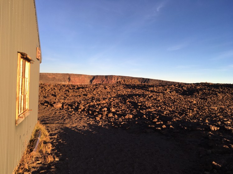
Today was a short day to the base of Mt. Whitney. Good thing too! I arrived around 2 PM and the hail snow turned frozen rain downpour started around 4 PM. I already had my tent up, new bug inner netting and bathtub tied and adjusted, PJs on, toilet scoped out, ranger station and snow station investigated, supper eaten, water bottles filled, and ready to stow away for the night. I looked over upcoming map sections, organized food for tomorrow, made a list of items to take up Mt. Whitney, set my alarm for midnight, and waited for a lull so I could take my food bag to the bear box and get a last pee in. I wanted to be tucked in by 4 PM but waiting out a lull took awhile. It sure is nice being dry and warm. It would have sucked showing up late to camp, having walked through the rain. I am glad I trekked larger miles the last two days. The plan is to wake up at midnight and be on trail by 1 AM for a sunrise ascent. I am in a group with Tami, Prickly Pear, S&M, and Concrete. We were all glad to have camp setup before weather began. It seems like afternoon rains are becoming the norm. I will have to start being more diligent in the mornings so weather doesn’t prevent my mileage goals through the Sierras.
This morning I woke up at 5:30 AM and rubbed out my legs and feet. My tent had ice covering the entire inside. I tried to quickly get around, and was almost ready by 7 AM. But I decided to let things completely dry out instead and got a 7:45 AM start. I quickly found Cobain, Fancy Feet, and Highwater a few miles down trail. Highwater took off right after me and we ended up hiking together off and on until the river at mile 762. That river and the meadow it is in are stunning! The most beautiful part of the day, easily. I found Tami and Prickly Pear taking a break in a sunny grassy area and I joined them. I decided to revel in the warm of the sun by the river, despite my intentions of no long rests today. I soaked my feet numb and washed some things. Pretty wonderful! And my hunger is back finally! It must been my body adjusting to the altitude. I am trying to put more liquids in me too.
I saw a group of deer today, coming into Lower Crabtree Meadow. That is right where the Whitney Spur Trail splits off from the PCT. They were hanging out, lounging in the sun. Back at camp, there were lots of people hanging around. Some resting after the summit, others deciding if they would stay for a summit tomorrow. We were planning to go the 1.1 miles up the Whitney Spur Trail to the Crabtree Ranger Station. I am glad we did. It cuts a mile out for tomorrow, but also puts us right at the junction for the John Muir Trail heading back to the PCT at mile 767 and the Whitney Trail heading to the summit. It is basically a 4,000 ft climb over eight miles. We are planning a sunrise ascent, then return to camp for a nap, and hopefully get in another nine or so miles to set us up for Forester and Kearsarge Passes the following day.
I should write more but I am supposed to wake up in six hours and hikers have begun filing in. Some more noisily than others. I am going to try and sleep now.
Day: 37
Mt. Whitney (14,505 feet)!
Day Thirty-seven: 8 June 2015
Start: HM 766.3 + 1.1 Whitney Spur Trail
End: HM 774.7 Tyndall Creek
GPS Point: 36.642935, -118.387701
Day Total: 23.9 miles
Water at mile 766.3 + 1.1 Whitney Creek at Crabtree Ranger Station, mile 766.3 + 3.5 Whitney Creek at Guitar Lake
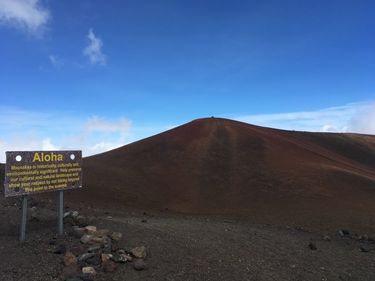
Last night Hoots found me in my tent. Hot Sauce, Ryan, and he had hiked in and were headed to Guitar Lake to camp. That put them about three miles closer to the summit. They hadn’t seen Chris and were hoping he would turn up at camp. I feel like I didn’t sleep much, but I was all energy this morning. Ready to summit a mountain. Mt. Whitney is 14,505 feet of elevation (some discrepancy says 14,508′). The highest mountain in the contiguous 48.
I woke up a bit after 12 AM and departed at 1 AM with Prickly Pear, Tami, S&M, and Concrete. It was awesome hiking in the dark. Everything looked completely different. We were hidden from the moon until coming up on Timberline Lake. It was stunning. You could see the moon shining across the entire surface. We stopped at the creek just before Guitar Lake to fill water, eat a snack, and regroup before the real climbing began. While there we saw Hoots, Ryan, and Hot Sauce start the trail. We followed suit and quickly it was Concrete, Ryan, and me leading the way. I made the top around 4:15 AM. Just over three hours for 4000 feet of climbing over 7.5 miles. It was freezing at the top, but surprisingly calm. There was frost on everything. I had zero feeling in my hands and toes. Not sure I’ve ever shivered so hard in my life! We were all bundled together like sardines waiting for the sunrise. Which didn’t occur until closer to 5:30 AM. But it was mesmerizing up there. To go from total darkness to standing on top of Mt. Whitney with possibly the best view I’ve ever seen. I can’t even describe it. The Sierras really might be the jewel of the PCT.
Once we saw the sun, we all huddled into the tiniest room of the shelter on the summit. There were eleven of us in total since Fancy Feet, Cobain, and Highwater joined us. Then two day hikers came in as well. It wasn’t exactly warm, but it did protect against the wind that picked up as the sun began to rise. I stayed up there until 6:30 AM, then booked it down. Though not so fast that I couldn’t take about one hundred photos of the peak, sunrise, our group, and the surrounding valleys and mountains as the sun began to spread its warm embrace. Since I hiked up in the dark, it was like a whole new trail going down. The lakes were almost more beautiful in the silvery moonlight. Saw heaps of people on their way up. Glad we did a sunrise hike. I was exhausted but it was worth every second. Back at base camp, I had zero energy. After shoving food in my face, I stripped off my clothes, put on my sleep socks, and napped in the full heat of the sun. Aww!
I slept hard. Concrete took off before I woke up. He is headed straight to VVR, four or so days ahead. The ladies and I relaxed and casually packed up camp. Our plan was to camp just before Forester Pass, a mere nine miles away, to set us up for the hike out of Kearsarge Pass into Onion Valley to head into Independence, CA. It was a pretty relaxed trek over. We are right by Tyndall Creek, about five miles below Forester Pass. This evening was warm and sunny. No afternoon storm like the past few days. We were joined by Boone and Endless (friends of S&M and Prickly Pear), Cat Lady, Aloha (the small backpack guy we kept running into until he delayed a few days at Big Bear to meet his wife), and for a short while Recon (he ate supper then headed out for the camp area a mile below Forester Pass).
Tonight was great. We all hung out and enjoyed good company. There was a small table and sitting area set up out of flat rocks that we chilled around. It was fun being with new people, hearing their stories, and having a change of pace. It sounds like all of us, except Aloha who is headed for Muir Trail Ranch, are headed for Kearsarge Pass into Independence. That group is planning on a hotel room in Independence then quickly getting back on trail. Tami is spending a few days with her parents. And I am still undecided. I have my packages in Independence, but would like to have time to get some chores done since they weren’t possible at Kennedy Meadows. Also, Bishop is supposed to be awesome and there is a hostel there. So I may take a nero and get out the following evening just for the hike back up Kearsarge Pass.
Today has been extremely long, I am exhausted. Goodnight.
Day: 38
A double pass day!
Day Thirty-eight: 9 June 2015
Start: HM 774.7
End: HM 788.5 + 7.6 Kearsarge Pass to Onion Valley with hitch to Bishop, CA
GPS Point: 37.36332, -118.39641
Day Total: 21.4 miles
Water at mile 774.7 Tyndall Creek, mile 787 Middle Vidette Meadow at Bubbs Creek
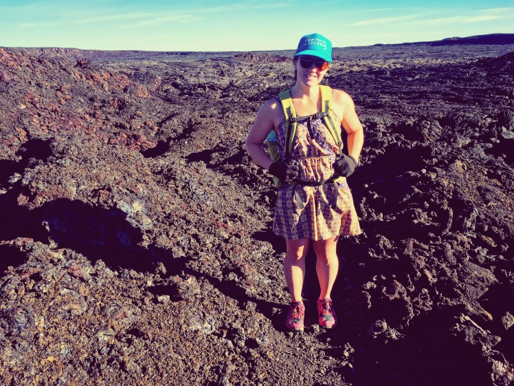
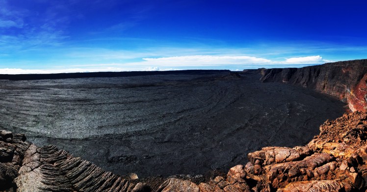
What a day! We hit Forester Pass first thing this morning. You spend four miles heading straight at this sheer rocky face, wondering what notch you are headed for. When you finally recognize the one you are destined for, the immensity of the pass suddenly becomes clear. Except Forester was a breeze. Maybe it is the ease of post Mt. Whitney climbing, but the switchbacks were short and you are at the top quickly. It is one of the most amazing views though! You can see forever to the north and south from the pass. Incredible! It is also the tallest official PCT point on the whole trail.
Speaking of which, I heard the Sierras referred to as the nine passes by two southbound JMT’ers. This is interesting because I feel like I am slowly and painstakingly putting together the reasons why mileage goes down in the Sierras. To me, the Sierras are like the CT and that’s where I thrive. I gathered that people slow down to really enjoy this section and take side trips. I’ve also heard it’s from the difficulty of the trail conditions. But what is beginning to make sense is that normally the snow conditions are significant and people would time the pass crossings to climb over only in the AM. That would definitely cut down on daily mileage abilities.
The day wasn’t finished after Forester Pass. After trekking through an incredible valley of meandering river channels, I headed straight up Kearsarge Pass too. Two passes in one day. I feel accomplished! The lakes off of Bull Frogs Trail towards Kearsarge were beautiful! I am contemplating trying to charge through bad weather predictions for tomorrow and head over the pass to camp by ow if the lakes.
I did a poor job at remembering names today. There were just so many people! Saw Snackies heading up Forester Pass. Met Grapefruit and Buttplug just before starting the switchbacks. They challenged me to point out Forster Pass, which I knew instantly. There is a pattern to where passes are placed… At the top, Ryan flew in out of nowhere. I was glad to see him. Met the two southbound JMT’ers. Spent the climb down from Forester into the valley chatting up with Aloha. Very interning guy! At lunch caught up with Cat Lady, Tami, S&M, Endless, Recon and Howley. After that began the climb to Kearsarge. Endless pointed out the Kearsarge Pinnacles to me. At the top of Kearsarge were Motown, Vortex, two others. Then got a ride from the Onion Valley trailhead with a nice man named Richard. He gave Cat Lady, Endless, and I a ride to Independence where we picked up packages, then into Bishop where he was also staying for the night. What a lucky hitch! There were surprisingly no people around. Richard is from Pasadena, CA, and he chatted us up about many things. Cool to have some things I will take mental notes on as I prepared to be living in this region of the U.S. Also learned he teaches violin in LA. I have always really liked that instrument.
In Bishop, CA for the night at Hostel California. We ate supper at Amigos Mexican restaurant. I am in a private room with Cat Lady, Tami (Townderwear, trail name we are trying out for her), Endless, and S&M. Finished the night off with milk and cookies my mom sent in my resupply box! She sent cookies, I bought the milk. Thanks Mom! So delicious! And a local Mammoth IPA beer. I threw away my holy socks and stinky, destroyed shoes! I received new shoes in my resupply, and plan to buy new socks tomorrow. My feet will be so happy! While letting food settle, I caught up on emails and such. Met Uncle Buck, S.P., and another guy. Uncle Buck skipped past the Sierras while they were receiving late snows and has just returned from two hundred NorCal miles. Tami, Endless, S&M, and I hung out late telling stories. I’ve decided Endless tells the best stories. Massachusetts native, fireman from Lynn, thick accent. Everything he says is gold.
Day: 39
Bishop is the shit.
Day Thirty-nine: 10 June 2015
Start: HM 788.5 + 7.6 Kearsarge Pass to Onion Valley
End: HM 788.5 + 7.6 Kearsarge Pass to Onion Valley
GPS Point: 37.36332, -118.39641
Day Total: ZERO
Water at mile Bishop, CA
This is my second zero day on the trip. I am really happy I took it here. I will skip the Mammoth one now. Bishop is an awesome town! Despite staying up late last night we all woke super early. Our room was like a sauna! Endless, Tami, S&M, and I went to the Looney Bean for coffee. I wrote some postcards and organized my town chores. It was so nice to feel like I had a calm moment to relax.
After coffee time I dumped my pack out in the hostel living room and organized everything. I have to carry the bear canister now and it makes me very unhappy. I realized not until now that my canister only fits in my empty pack and not with all my gear. Sad. Snackies hikes with his bear canister empty on the top of his pack, so I discussed some options with him and will be doing something similar. My food situation was perfect for the number of days I will hike to Mammoth in, but I had some other chores and items I was looking for. Endless and I walked to the Post Office, then checked out a few of the outfitters. I found all the things I needed! Two pairs of new socks, Tyvek ground cloth, two plastic toggles, Aquamira, and other stuff. Today was very productive! I received new shoes in my resupply box! My feet will be in spoiled heaven! I also ate so much food. Humus, blue corn chips, milk, delicious homemade cookies from my mom (Thanks again Mom!!!), and beer. Then S&M, Endless, Snackies, and I went and ate barbecue. I picked up a savory croissant from Schatz Bakery for tomorrow’s breaky. I also have yoghurt, orange juice, and a banana. I am pretty excited!
After BBQ, I found Hoots and Hot Sauce watching Jurassic Park at the hostel. Ryan was organizing food. Chris’s whereabouts still unknown. After all that eating I really wanted a nap but we needed to head to Independence. S&M, Endless, and I walked to the Vons to catch the bus. It started raining heavily while we were at the bus stop. We then had a ridiculous ride. Details and frustrations aside, there was a particularly unsavory guy who mistakenly thought everyone wanted to be privy to his every thought and opinion. Longest 42 miles ever.
Once in Independence, we went to the Courthouse Motel where they have a bunkhouse for hikers. It’s actually a pretty neat setup. There are bunks for 14 people, one bathroom, and a simple kitchen. I continued my chores with cutting the Tyvek and rigging up the bear canister on the top of my pack. S&M’s and Endless’s friends were there too. Prickly Pear, Boone, Queen Bee, Baby Killer, and Malibu. It was fun hanging out, but we eventually thought about our return to the trail tomorrow and headed to bed. S&M and I were treated to a bedtime story from Endless. He’s reading Into The Wild right now.