2/1/2018
Geologizing around Oldonyo Lengai
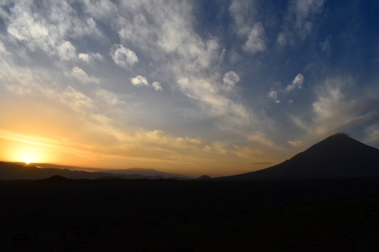
Melissa and I continued our morning ritual by watching the sun rise over the flank of Gelai volcano from the edge of camp. It is nice to have freedom of movement again! Then Kimambo outdid himself this breaky feast: soft cinnamon bread twists, eggs, bacon, mango, pineapple, passion fruit, hot tea with milk, and my daily dose of EmergenC. Maybe the meal was not all that different from other mornings, but we were excited to be switching our focus to rocks!
For the past 20 million years or so, this part of northern Tanzania has witnessed two major periods of extensional crystal deformation, both followed by pulses of volcanism (Dawson, 2008). Instabilities in the mantle during late Tertiary time caused regional uplift and the formation of an irregular, domed highland. Extensional faulting along the crest of the domed structure, formed three diverging grabens: Natron, Eyasi, Pangani. In fact, more recent normal faulting throughout the Oldupai region may have originally developed along these older structures. Within this tectonic depression, numerous single mafic shield volcanoes (Gelai, Kitumbeine, etc) formed, while others coalesced into larger volcanic provinces (Mt Kilimanjaro, Ngorongoro volcanic highlands, etc). Renewed extension during the upper Pleistocene formed a half-graben with faulted margin in the west. This is the East African Rift as known today. Lakes Natron and Manyara developed within local depressions adjacent to the western rift margin. Finally, renewed volcanic activity on a much smaller scale activated Mt Meru, Kerimasi, and Oldonyo Lengai. Kerimasi and Oldonyo Lengai are the only two that have erupted carbonatite lavas. Oldonyo Lengai remains the only active volcano in Tanzania today, and the only active carbonatite volcano in the world.
Our first aim for the day was a place on the USGS map named “Ildonyo Loolmurak,” a small cone next to a volcano called “Loolmurak crater”. Daniel told us the local name for the crater is “Kerimasi” and the cone has no name. I enjoyed how “oldonyo” was spelled “ildonyo,” as ‘mountain of the crater.’ I have not investigated how the USGS determined the names of these cones, but it does beg to wonder whether they went straight from old papers, repeating the errors of early researchers, or consulted a local knowledge source.
The target material was to look at the lava flows from the small crater. From walking down the cone’s flank, it looked like 3-4 different lava flows of olivine melilitite separated by light-colored nephelinite layers. Everything was pretty weathered, but we observed large (1-3mm) olivine phenocrysts and abundant vesicles in the melilitite. The nephelinite was hardly worth hammering off a piece.
Then we stopped at a debris flow mound Danial called “Lollkimojok.” It is supposed to be a debris mound overlying a distinct phonolite lava dome, according to the USGS map. We found plenty of phonolite lava, but nothing in situ suggested it was independent of the debris flow material. I won’t say we throughly investigates the matter, but all the phonolite “outcrops” were higher on the mound than debris material, completely lacked any type of contact suggesting either burial or intrusion, and frankly looked like it was locally transported with the debris material. Like I said, we didn’t investigate on any major level, but this unknown relationship remains a mystery to us.
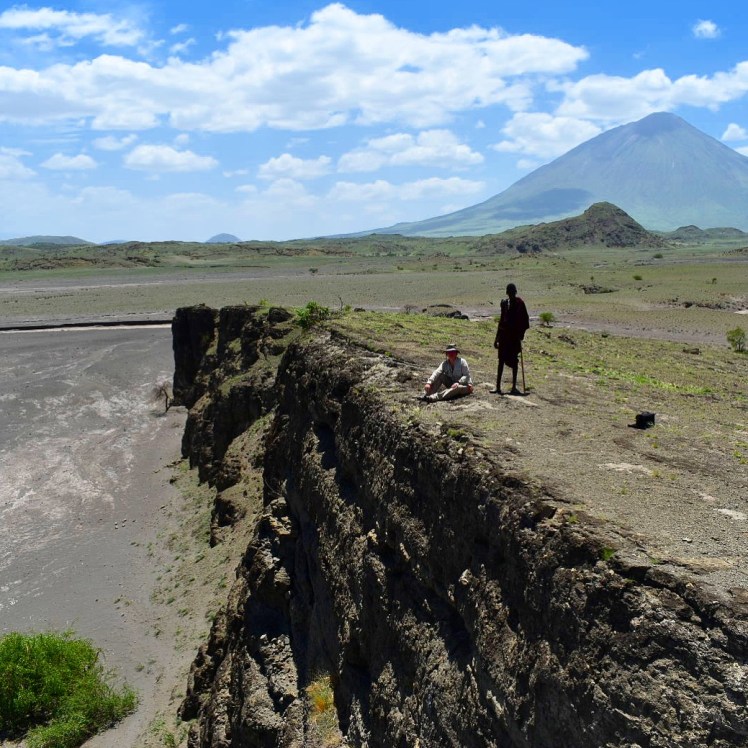
Near the NCA gate we also stopped at an active fault locale. It was as close to active faulting as I have ever seen. There is old uplift creating an ~50m cliff overlooking the lake bed below. Behind the cliff are a series of cracks parallel to the cliff face revealing active graben formation where this crust is stretching apart. The most prevalent crack, about 50m back from the cliff and 10-15m deep, is supposed to be less than 20 years old. Geology on a human scale! We could see bats flying around in the shaded portion of the chasm.
We kept today relatively low key because it is exhaustingly hot in the baking sun, and we are preparing for a nighttime summit of Oldonyo Lengai!
As already mentioned, Oldonyo Lengai is the only active volcano in Tanzania and the only active carbonatite volcano in the world. Thus it might also be one of the most famous volcanoes in the world. Early explorers thought the light coloring was snow, but it is actually light colored carbonatite ash and how the minerals in the lava weather to a grey color. The volcano is deeply incised by deep, radial gullies. Much of the eastern side was blown out by a violent eruption 2,500 years ago, and that eruption caused a large landslide scar still visible on the northeast face. Much of the landscape around Oldonyo Lengai are the remnants of large debris flows covering the east to northeast flanks. The most recent eruptions took place over 2007-2008, with lava flows and large ash eruptions that caused a lot of destruction and some mortalities in the small town of Engaruka.
Oldonyo Lengai, a nephelenite-phonolite-carbonatite stratovolcano is estimated to have begun ~0.37 Ma (Klaudius and Keller, 2006). Lavas of Oldonyo Lengai are geochemically diverse, erupting combeite-wollastonite-nephelinites, phonolites, and natrocarbonatites (Klaudius and Keller, 2006). Of the known extrusive and intrusive carbonatites, only the lavas at Oldonyo Lengai are natrocarbonatitic (Woolley and Church, 2005; Jones et al., 2013); thus these lavas are unique and have no other direct comparison in the geologic record. The unparalleled major oxide compositions, trace- and rare-earth-element geochemistry, isotope systematics, and volatile concentrations of Oldonyo Lengai natrocarbonatite lavas give igneous petrologists insight into deep carbon systematics, mantle processes, magmatic differentiation due to liquid immiscibility, and carbonatite petrogenesis (Simonetti et al., 1997; Dawson, 1998; Keller et al., 2006; Klaudius and Keller, 2006; Potter et al, 2016).