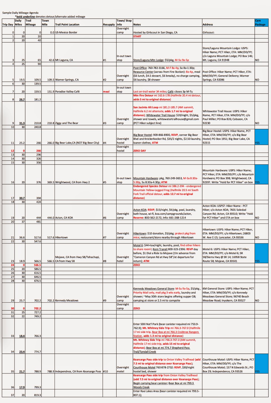
Mile 566.4 Tehachapi to mile 702.2 Kennedy Meadows
10 June 2015
Mile 566.4 Tehachapi to mile 702.2 Kennedy Meadows
Day: 28
The last desert stretch.
Day Twenty-eight: 30 May 2015
Start: HM 566.4
End: HM 585.8 on ridge saddle
GPS Point: 35.24782, -118.25135
Day Total: 19.4 miles
Water at mile Tehachapi, mile 583.3 Golden Oaks Spring
We had a slow start this morning. We packed up and headed to the bakery for breakfast and a hitch back to the trail. We were sitting with the German guy (found out his name is Scooter) when this woman walked up who Ben and I had met yesterday at the Post Office. Her name is Carol, or Lupen Fields, and her husband Chris, or Buck Snout. She had offered us a ride but we never called so thought that wouldn’t be an option. Instead, they were these genuinely nice and interested people. They had gone over to the airport looking for us and At Home must have told them we had headed for breakfast at the bakery, so they came to pick us up. What a surprise and so wonderful of them! Buck Snout has been section hiking the PCT for many years and is finally doing the last part this July. Lupen Fields is driving out a small trailer to stay in while he’s hiking and she plans to trail angel up there while they are in the area. I cannot believe how nice they are. It’s possible I will run into them if I finish the trail in early August.
Anyways, wonderful encounter, but that put us back on trail at 8:30 AM. A solid two hours later than we would normally start. That is like removing the time frame for four to six miles. It sort of threw off our whole day. We stopped around 11:30 AM for our afternoon break. We all passed out hard. We were back on trail just after 3 PM. We hit today’s water source around 6 PM. That was a slow fill up for the next 20 miles. Especially with eight of us filling from the same steady trickle. Then we hiked on another two miles or so. This last 150 miles into the Sierras is the driest section. We will only cross water about once a day, and will likely have dry camps the whole time. I am proud of our 20 miles with the way timing worked out for everything. We saw that at least twenty people came through the water spot today, so we want to stay on track for this section because we will all be vying for the same limited water supply. Also we just want to get through the back side of the herd. At least I want to. I am weary to think of hitting the main herd not until after already entering the Sierras. Camping and trail traffic will be dreadful.
Found out Slug is third guy’s name with Trout Sniffer and Boom Box. They are all from L.A. Also a couple we keep running into are Wildcat and Yellowtail. Saw some register names of people we have been getting closer to and some new names I haven’t recognized. The list only went back to mid May. Golden Oaks Spring has unfortunately become a bit of a trash heap. There are old water bottle cases that have had numerous bottles and other trash packed into them, as well as several actual bags of trash. Disgusting.
Today was beautiful. I kept wondering the whole time what was different about today. Then I realized I have seen trees today. We didn’t go through a burn area and saw what this terrain would look like uninterrupted. It was delightful and shady. Surprising what a lack of recent fire history can do for the appearance of a place, regardless how hot and dry the area is.
I am glad I slept this afternoon, but sleep is still dragging heavily at my eye lids. Last night I didn’t go to sleep early enough, so tonight I want to make sure I do.
Day: 29
Beginning the Sierras.
Day Twenty-nine: 31 May 2015
Start: HM 585.8
End: HM 608.9 Landers Meadow in Kelso Valley
GPS Point: 35.45428, -118.31433
Day Total: 23.1 miles
Water at mile 602.1 Robin Bird Spring, 608.9 Landers camp
Today was hot by 9:30 AM. Bummer that we had already decided to go all the way to the water source before stopping for siesta. We rolled in after noon and I was beat. Though I slept really well last night. It was the perfect temperature for sleeping.
At the water source I ended up setting camp by a group of guys. Three brothers: Pogo, Sticks, Shades, a speed attempt guy: Flash, Concrete, and the couple who just got married on trail: Big Spoon and Hands. Interesting to listen to others talk about their hikes so far. Saw Scooter, Trout Sniffer, Boom Box, and Slug. Second Lunch from last night’s camp spot.
Around 5 PM we took off for the next water source seven miles away. It was cool, shaded, and such a lovely jaunt. The idea was to hike past the water source, but it is in such a beautiful ponderosa and sage meadow that we stayed to camp. Landers Meadow in Kelso Valley. Stunning! There were these tiny red flowers with the sun peaking through at them. It was beautiful and awe inspiring.
Today Ben expressed his feelings on people talking about their lives prior to being on the PCT as their “real life.” He dislikes the connotation that what we are doing right now is not real life. It got me thinking and I agree. My life has been marked with many instances of “non traditional living.” All four years of college I changed residence locations and roommates each year, then I traveled in South America for ten months, my first job was working in a trailer across northeast Colorado, followed by working in an office, now I am living on the trail. My habits and routine have constantly changes depending on what is going on in my life at that time. To talk about this adventure as being something outside one’s real life suggests we are not living. I have always been a firm advocate of spending my life doing things that make me happy. I work to live, not live to work. And my play time is the most important thing I do each day. Hoots added a new dimension though, he dislikes the word vacation. Vacation harbors a reward mentality. Work hard and you get a break to do things you enjoy. Rather than making everyday enjoyable. Or putting more effort into making sure our every decision about how we spend our time is focused on always enjoying ourselves. Not just living for the weekend, or vacation time. I like that thought process. It is why I struggled so much with an office job. I need more flexibility each day with my hours to fit them around the other activities I want to do. Ideally we all get to live our careers/jobs, but realistically all work eventually feels burdensome at some point. Something my Aunt Marilyn instilled in me is to make sure I spend each day living for myself, because you never know when it is your last. That may sound cliché, but I will die with no regrets.
Day: 30
Thirty miles on day thirty!
Day Thirty: 1 June 2015
Start: HM 608.9
End: HM 637 Yellow Jacket Spring trail
GPS Point: 35.58815, -118.13272
Day Total: 30.1 miles
Water at mile 620 Willow Spring
So many things to say for today!
First, we woke around 4 AM this morning. It was still dark and chilly. I was on trail at 5 AM. My earliest day by over an hour. I saw so many pretty sunrise views. And there was a playful warbler that fluttered about in front of me. Yellow breast, patterned black feathers on it back and wings, and a red mask across its eyes. Quickly the miles passed. Likely because my brain didn’t wake up until I had already been hiking several hours. Hoots and I split off the trail at mile 620 to head to Willow Spring. It’s a 1.4 mile trail down a drainage path for a 700 foot drop to a spring. The spring is a ground seep up into this shallow, fetid pool. Filled with snails, frantic red worms, snakes, insects, algae, and more. It smelled of decomposing matter. We filtered water from here and treated. My second opportunity to have Ben provide me with his filter. I had just under two liters when we showed up. Had I been on my own, I would have skipped that source and booked it forward to a rumored water cache ahead. But with filter, the water was fine. There was a lot of water too. I think the pipe system used to be reliable in the past, but we had to go with stagnant pool instead. It took an hour to filter water for both of us. We hiked away from the water source up a jeep road back to the PCT. Basically 1.6 miles back up the lost 700 feet. It’s a 3.2 miles alternate to 1.9 PCT miles. We hit the spring about 9:30 AM and took off an hour later. There were so many incredibly large Joshua Trees down towards the spring. Incredible!
Anyways, once back on trail, we decided we would hike at least four miles. There was a strong breeze that had picked up. At mile 623 we encountered a couple who are running a water and supply service for the next two weeks. They bring water and supplies out from Mojave that people have paid for. That way hikers know they have good water halfway across the long waterless stretch. In my favor it meant they were just posted up and were giving out cold soda! Nothing like a cold sugary drink when you’ve just hiked up a hot road to be smacked in the face with a blustery and hot trail. It was such a nice surprise! We stayed long enough to finish the drink then continued on. We weren’t going to siesta because the wind was so cold, but both of us needed rest and food. We stopped at mile 625 and took two hours. We attempted naps but the wind was genuinely cold in the shade and too strong for me to be comfortable. At one point Hoots had a bird literally fly into his back haha! I just couldn’t find comfort or rest, despite being exhausted. We decided to keep moving. From there we only had 12 miles to the next water source.
There were lots of people hiking today instead of taking afternoon shade breaks. The majority of today’s trail was on ridge line and very exposed. I doubt anyone found much comfort in rest with the wind blowing so hard. There were three major water caches today. I was not expecting any of them. Though I did greatly appreciate the bit of trail magic with cold soda. I met The Eggs, saw Concrete, Clay and Mighty Mouse, Marian, and several others. There were registers again today and it sea like we are just behind a big crowd of people. The bright of of a long day today is that weather is supposed to remain chilly and windy the next two days. So at least I don’t have to get up at 4 AM again tomorrow.
At mile 632 we started a big climb! I wasn’t ready for it. Luckily the grade was super easy. But we did climb a lot. After getting to the top, we slowly started climbing back down. At mile 637 we split off down Yellow Jacket Spring trail. It is 0.7 miles down off the PCT. Hot Sauce and Marian were already set up with camp and eating supper. I was ready to curl up and pass out. At least the wind did die down a bit, thankfully, as might set in. It will be chilly tonight.
Day: 31
We have reached the desert-Sierras cusp!
Day Thirty-one: 2 June 2015
Start: HM 637
End: HM 663.7 Joshua Tree Spring
GPS Point: 35.74218, -118.02366
Day Total: 27.7 miles
Water at mile 637 Yellow Jacket Spring, mile 651.3 Walker Pass campground, 663.7 Joshua Tree Spring
I slept in this morning! So great! I rubbed out my legs and feet. None of us got water last night and this morning revealed we needed to filter it. It was less abundant than the Willow Springs water, despite being cleaner. I waited until Hoots finished filtering then borrowed his filter to get two liters for myself. I carried his filter so he wouldn’t have to wait for me. I left camp at 7:45 AM and was back to the PCT by 8:00 AM. The plan was to go 14 miles to Walker Pass for lunch. I booked it as fast as possible. The first past was so beautiful. Then we walked a dirt road right into a burn section. I don’t know if we have had a single day this whole trail that didn’t go through some part of a burn area. Sad to think about. A few miles out from Walker Pass I crossed paths with two older guys out day hiking who gave me a mini Pay Day candy bar. So sweet of them!
I strolled into the Walker campground to find Ryan still there and two hikers who were dropped off: Starboard and Good Times Grant. They gave me a chilled orange and strawberry lemonade Powerade! Plus, I found cold Bud Light in a cooler! Best lunch and trail magic! Hot Sauce, Hoots, and I hung out there a good two hours. We decided that we should hike to the next water source. Water past Walker Pass is all supposed to be relatively abundant and easily accessible. I am so excited!
Leaving Walker Pass is like the beginning stages of what is to come in the Sierras. There were rocky granite cliffs, sheer drop off ridge line walks, living trees, and the beauty of high lands. I am so excited! I took so many pictures. I decided I needed to book to the last section too and made surprisingly good timing. All day I was moving consistently fast.
The day’s endpoint goal was Joshua Tree Spring. 1/4 mile off trail down in a river valley. The side trail is surprising steep down to it. But the water was an easy piped spring. Mosquitoes were buzzing around everywhere but a girl named Let’s Party with her dog Easy (trail name Bottoms Up) and Concrete had started a fire. The smoke was helping with the blood thirsty demons. I filled my bottles, hung out a little while, then headed back up the side trail to camp closer to trail. It is less buggy and less distance to walk with my pack in the morning. Not that I didn’t walk all the way down there with my pack. Ryan, Chris, Hot Sauce, and I are all cowboy camped on a sloping spot with Hoots and Pink Leprechaun close by. More people showed up and there are at least four or five camped down by the spring. Apparently there have been reports of bears in this area down by the spring. Interesting to start changing gears and thinking about bears and cold versus rattlers and the blazing sun.
I am sure there might have been more on my mind today, but sleep is winning.
Day: 32
One month down and a quarter way finished.
Day Thirty-two: 3 June 2015
Start: HM 663.7
End: HM 693.5 Manter Creek in Rockhouse Basin
GPS Point: 35.924663, -118.149306
Day Total: 30 miles
Water at mile 669.4 2nd crossing of Spanish Needle Creek, mile 680.8 Chimney Creek
To celebrate my one month on the PCT, and that we crossed the quarter way point, I slept in this morning. The original plan was to hike 23 or 24 miles so I knew it would be pretty relaxed. I spent a solid thirty minutes rubbing out my legs and feet, I ate my cereal for breaky, I watched others wake up and put themselves together, then I had to get up to pee so started getting around. I left camp around 7:30 AM with Chris, the last two to leave, and I took off. I knew we would likely hike the six miles for quick water then the eleven more for second water before stopping for lunch. Despite leaving last, I beat everyone there except Concrete, who legitimately left over an hour before me and hikes fast. Ryan is also a fast hiker, but I passed him while he stopped for a pre lunch snack about four miles out. It was so nice not needing to carry a lot of water weight while also having a basically empty pack. I like the short early miles while packs are full and then progressively hiking further when the pack weight diminishes.
En route to lunch, there were these biologists hanging out on their lunch stop before heading out on an onion mission. Apparently there is a rare onion out here that was last observed in the 80’s up in a steep scree area by the granite peak spires. They were hoping to find this onion then start developing a conservation plan for it. Ryan was excited to maybe find one from the trail but one of the biologists told him there is a poisonous plant that mimics the rare onion. Pretty crazy.
Lunch was great! I met a bunch of people who’s names I no longer remember. Roadrunner was one. The river was full and thriving. We took a 3-4 hour lunch break. I soaked my feet, rinsed my button up shirt, dunked my hair, tried cleaning my legs and arms a bit. So cold and so refreshing. The sun was hot and we are at a higher elevation now, but the cool breeze was perfect for hiking. I hiked without my over shirt all morning until the last stretch into lunch. Then the rest of the day after it had a good rinse, no longer crunchy with salt.
While hanging out, we were looking at the maps and thinking about our neros in Kennedy Meadows. We decided that less miles tomorrow the better. So the plan was to hike 12 more miles instead of only 5 or 6. Since we didn’t leave from lunch until 4 PM, it was a gamble if we would end up night hiking. But we arrived at Manter Creek just before 8 PM and it is down in a valley where the sun was still shining. Perfect timing! I think that’s pretty good for a thirty mile day. Hot Sauce, Hoots, Ryan, and I made a pretty solid day of hiking.
There are several people who were already in bed when we arrived. We splayed out on the nice level sand, cooked our suppers, and hung out a short while before retiring to bed ourselves. Tomorrow we have a quick 9.5 miles into the store at Kennedy Meadows. As the name suggests, we will have a breeze of flat valley hiking.
I know I am forgetting things, but that’s all for now.
Day: 33
Sweet Something.
Day Thirty-three: 4 June 2015
Start: HM 693.5
End: HM 702.2 Kennedy Meadows store
GPS Point: 36.01953, -118.12412
Day Total: 8.7 miles
Water at mile 702.2 Kennedy Meadows General Store
Today felt like a real accomplishment. We are done with the desert and beginning the Sierras. It is great to feel like one “eco zone” is finished. Next up the Sierras. We won’t need to track the water report soon, miles are supposed to go down, and all our training thus far will begin anew. Now will begin cold weather, rain possibilities, bear considerations, granite trail and rock obstacles, river fording, and whatever else. Everyone says mileage goes down in the Sierras, so I am interested to see what the differences are.
We made it to Kennedy Meadows very easily. An easy, rolling walk. We did pass by a cool abandoned cabin. A once used, long forgotten treasure. No roads leading towards or away. Maybe a hunting lodge or winter hideaway. I would like living away from everything for awhile. Town visits for supplies. Life tucked up in a simple nook of a home, a cabin in the woods.
While walking up to the general store, all the hikers started applauding. How fantastic a feeling to reach this next page in the hike and feel the acceptance, understanding, appreciation, and sense of community from all these people who have just gone through the same path as you. A different journey for each of us, but one we took together. This was a sweet something for me.
I immediately found a seat at a table on the porch and removed my shoes. Next I wandered through the store, bought Frito’s and bean dip, and inquired about all the chore options and available amenities. We arrived at 10 AM and we’re ready for burgers when the grill opened at 11 AM. I had a double cheeseburger with guacamole, lettuce, pickle, and tomato. Delicious! Also very filling. I washed everything down with beer and a giant Gatorade. After assessing my resupply box and food situation to Independence, CA, I mostly just relaxed and did a lot of nothing. Took a glorious hot shower, scrubbed my clothes in a wash tub, chilled out in the cool sun.
There were heaps of hikers at the general store! I saw some people I haven’t seen in a while, Concrete, Pink Leprechaun, S and M, Snackies, Tami, Sugar High and Subway, and others I met more recently. Magic took off yesterday and Brandon took off this morning. I also met a bunch of people, especially Cat Lady, Rock Star, Square and Veggie, and others whose names evade me. It was awesome and the right mix of town and hiker trash. I think because there is no reception or Internet, options limited to just the general store or a restaurant a couple miles away, and everyone feeling the accomplishment of the past 700 miles, the vibe is just right. I literally called my parents on a pay phone to organize some trail logistics. You can be sucked in but there is not enough to keep you on the bait. The general store is a business that hikers cater to and not vice versa. Everything here runs on generators, so when the store closes at 5 PM everything shuts down with it. No shower stalls, no water, no store or food, no power. We are left to our own devices. This is also the first place most people pick up their bear canisters. I think that humbles you a bit when you realize you now need to deal with this giant, hard canister. Weight is added for the canister and snow/bug/alpine conditions. A whole new page to this learning lesson.
Ryan bought hot dogs with a dream of a fire. We definitely did it up with style. Hot dogs and buns over the fire with a mustard and ketchup condiment mix, fried instant Idahoan mashed potato latkes, and Ben and Jerry’s for dessert. I actually had one and a half pints ice cream, the rest of my Frito’s, and an Idahoan on the side, too. Calorie loading galore! Anyways, it was a great time hanging out by the fire all evening. Fantastic company and ambitions for what’s to come. I don’t think any of us know what tomorrow will bring.
It is late now and beginning to be chilly. So much to think about and plenty to do in the AM before hitting the trail.